
Learning Resources
Lesson
Functional components of GPS
The Global Positioning System was built by the US military for tracking movements of troops and equipment. It is widely used for many other purposes by all nations.
This information is provided in real time, and readings are made at set intervals (every second, for example) and can be recorded. This data is used, for example, to determine location, speed, direction of motion, estimated time of arrival at a destination, plot courses, and so on. The information can be recorded and played back for future use.
GPS has the following
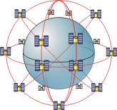
- Space segment. An average of 24 satellites orbit the earth in 6 orbital planes, with 4 satellites in each plane. Orbital time for each is 12 hours. At any given time, any point on earth can see between 5 and 8 satellites.
- Control segment. There is a series of ground based tracking stations around the world and one ground-based master control and monitoring station. Control provides an accurate time reference and orbital information to all satellites and ground stations.
- User segment. This consists of the GPS receivers owned by users of the system.
The global positioning system is used to determine the exact locations on earth or in the atmosphere. Four pieces of information are provided
- latitude
- longitude
- altitude
- GPS time
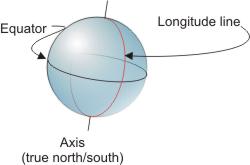
Latitude and longitude are an absolute reference system for locations on the surface of the earth. It consists of a set of imaginary grid lines. The earth is a sphere. Spheres, like circles can be divided into 360°. Each degree has 60 minutes and each minute has 60 seconds. One degree of arc on the earth's surface corresponds to 111.6 kilometers. One degree has 60 X 60 (3600) seconds. Each second corresponds to 31 meters on the earth's surface
Longitude
Longitude lines are circles around the surface of the earth, passing though the poles. Each longitude line divides the earth into two hemispheres. The starting line is one that passes through Greenwich, England. It is 0 degrees longitude. Its also referred to as the prime meridian.
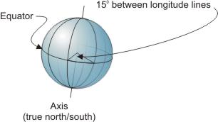
On globes, maps and charts, longitude lines are usually shown every 15 degrees, incrementing as you move west from England. The diagram below illustrates this. Note that the angles are not accurate.
Latitude
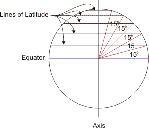
Lines of latitude are lines that are parallel to the equator. The equator is, in fact, 0° latitude. Lines of latitude are also usually drawn every 15°. Placement is determined by measuring angles from the earth's centre as shown in the diagram.
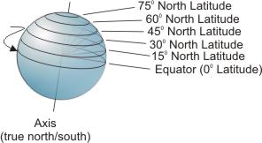
On a globe, lines of latitude appear like the next diagram. Only the northern hemisphere is shown.
The Latitude and Longitude Coordinate System
Combining latitude and longitude lines on the globe gives the system shown in the next figure. Note that the southern hemisphere is a mirror image of the northern one. Also note that the number and spacing of longitude lines is not accurate in this diagram. Its purpose is to demonstrate how latitude and longitude lines are placed.
Any location on the earth's surface can be specified as degrees longitude and degrees latitude. Gander, for example, is located at 48° 58' 06" N latitude - 54° 35' 33" W longitude. To determine the lat/long for your town or school, go to http://geonames.nrcan.gc.ca/search/search_e.php and type the place name into the search tool.
Altitude
Altitude is the height, in metres (or feet), above average sea level. A common standard is established and used on all maps and charts.
How GPS Works
GPS satellites orbit the earth at an altitude of 19,200 km in a constellation of 24. About 21 are active at any time.
A GPS receiver gets a continuous signal from all satellites that it can see. Each satellite's signal contains an id code, ephemeris data (satellite status, time, and date), and almanac data (where the satellite is located). The receiver takes the information, determines time differences and performs very complex calculations to identify the its exact location. The location is displayed on a map and in latitude and longitude. Altitude is displayed relative to mean sea level.
The diagram illustrates location of a point on the surface using information from 5 satellites. A minimum of 3 is required.
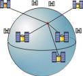
GPS can determine position to an accuracy of a few meters anywhere on the surface of the earth.
For additional information on how GPS works, go to
Be sure to read all the pages in the article, especially the one on how GPS works. It has a neat animation showing how a position is determined.
Activity
Assigned activities
Develop presentations on the following
- Describe, in general terms, how the GPS system determines latitude, longitude and altitude.
- Demonstrate applications for GPS in transportation
Starting points for research
- http://www.trimble.com/gps/index.html (GPS tutorial)
- http://www.carnav.com (virtual tour of automobile system)
- http://www.colorado.edu/geography/gcraft/notes/gps/gps_f.html
- http://www.gorp.com/gorp/activity/hiking/skills/navigation/main.htm
- How to Use a Compass
- http://www-spof.gsfc.nasa.gov/stargaze/Slatlong.htm (latitude/longitude info)
- http://www.confluence.org/index.php (pictures of locations on the earth at the intersection of major latitude and longitude lines)
- An Overview of the Global Positioning System (GPS) (technical discussion)
- http://www.epinions.com/otdr-Electronics-All-Hand_Held_GPS/_redir_att__~1
- http://www.thegpsstore.com/site/ (useful to see some of the products avaialble)
- http://celia.mehaffey.com/dale/pilotgps.htm (ways to use the PalmPilot with GPS)
- http://www.thalesnavigation.com/pages/agGps.htm
- GPS - A new Constellation - Smithsonian
- http://opensourcegis.org/
- http://www.garmin.com/aboutGPS/index.html (how gps works)
gis simulators
Test Yourself
There is no self test for this lesson.