
Learning Resources
Lesson
Loran stands for LOng Range Navigation. It consists of a series of radio transmitters that send pulsed radio waves.
The system is used mainly for coastal and ocean navigation. It is currently being phased out and replaced with GPS.
The system consists of groups of transmitters called chains. Each chain has one Master Station and several Secondary Stations. Transmitters are located in various places around the country such that the radio signals from a number of stations can reach any point. This is analogous to many AM or FM radio stations covering the same geographical area. A station can be included in multiple chains. In one chain it may be a master station, and in another it may be secondary station.
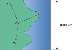
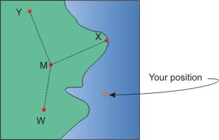
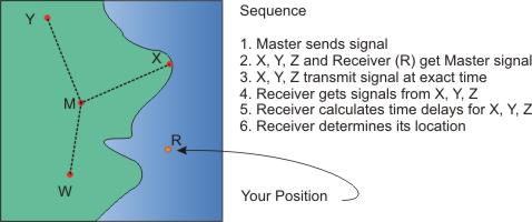
A typical chain is shown below with a Master (M), and three Secondary Stations. (X, Y, Z). Note the scale of distances between stations. Many chains are spaced further apart.
IThe sequence of operations is
- the Master station sends out a pulsed wave on a 100 kHz carrier wave. This is done repeatedly at set time intervals. The intervals, called the GRI (Group Repetition Interval) are different for each chain and are used to identify the chain.
- Each secondary station, after receiving the master signal, waits a predetermined time, and transmits its own pulsed radio wave.
- The Loran C receiver receives the Master signal, followed by the signals from each of the Secondary transmitters in the chain.
- The receiver measures the time differences in signals, in millionths of a second, and calculates its position.
Signals from a Master and two Second stations are required to determine location. A TD (time delay) is calculated for each Secondary, which is used to determine location.
The diagrams below shows an approximation of what happens
Because Loran C uses very tiny time differences to calculate location, anything that causes changes in the time that the signal requires to get to the receiver can cause inaccuracies. Rain, fog, snow, and even the shape of the land can alter the time that the signal requires to get to the receiver. Error correction charts are published periodically and are used to minimize the errors.
Maps of Loran C coverage areas can be seen in pages 10-19 of this pdf document at the Canadian Coast Guard web site. These may be helpful in visualizing the coverage areas in Atlantic Canada.
Activity
Assigned activities
For NEWFOUNDLAND EAST COAST LORAN-C CHAIN GRI 7270 and CANADIAN EAST COAST LORAN-C CHAIN GRI 5930, identify the Master Station and Secondary stations by
- station name,
- location
- latitude/longitude
- time delay of the signal from secondary stations
Note that time delays are in microseconds—millionths of a second. Microseconds are designated by μ second. μ is the Greek letter mu. This is the time interval from the Master Station signal until the Secondary Station sends its signal.
Information can be found at the Canadian Coast Guard web site, in this document.
Additional Loran C References
- http://www.garmin.com/manuals/lorantd.pdf (a good section on Loran C)
Test Yourself
There is no self test for this lesson.