
Learning Resources
Lesson
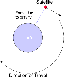
Satellites are objects that we have launched into orbit. They travel in a path, or orbit, around the earth at a speed that keeps them from being pulled to earth by the earth's gravity, while at the same time not so fast that they overcome the force of gravity and fly off into space.
To see the effects of changing the strength of the force that is causing the satellite to move forward, check this online animation. You may have to wait a bit for it to download.
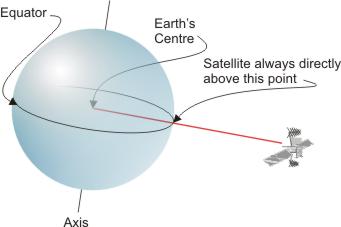
Satellites always orbit the earth as if they were directly above the centre of the earth. If you could connect a line from the earth's centre to the satellite it will exit the surface at right angles to the tangent to the surface.
Orbits
- Geostationary. Satellites in geostationary orbits maintain a position above the same spot on the earth's surface at all times. Geostationary satellites are directly above the equator and approximately 36,000 km above the earth. At this height they travel around the earth in the same time it takes for the earth to make one rotation, thereby staying directly above the same point on earth all the time.
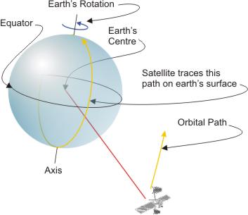
- Polar. Satellites in polar orbit travel in a path that takes them over each of the north and south poles during each orbit. These satellites cross the equator twice during each orbit but on opposite sides of the earth. The orbit is approximately at right angles to the equator. Since the earth rotates once per day, in each orbit the path moves a bit further west. Over a period of time a polar orbit takes a satellite over the entire surface of the earth.
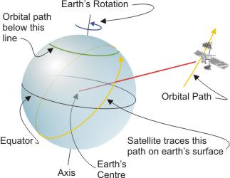
- Inclined. Satellites in these orbits travel at an angle 'inclined' to the equator (and the axis of the earth's rotation). These satellites never travel over the earth's poles. The orbital plane is at an angle (> 0 and < 90 degrees) to the equator. In the example below, the satellite's orbit traces a path on the earth that will always be below the green line. The situation is exactly the same in the southern hemisphere. As with polar orbits, the earths rotation ensures the coverage of the earths surface is complete, with the exception of the zones around each pole above and below the orbital path
Communications satellites
Communications satellites are used for voice, radio, data (including internet), messaging, navigation, remote sensing, search and rescue, and tracking. Communications satellites work in the following way
- An earth station 'uplinks' to the satellite and sends the information via an electromagnetic wave of fixed frequency. Typically it uses some form of dish to send the signal.
- The satellite, in geostationary orbit, receives the information, processes it, converts it to a different frequency, and amplifies it.
- The satellite broadcasts the signal back to earth. The reception area or 'footprint' usually covers a large area of the earth's surface. The shape and location of the footprint can be modified.
- Earth stations located in the footprint area use antennas to receive the satellite signal
Each satellite has multiple channels, called transponders. Frequently, each transponder carries multiple signals.
There are many types of satellites, including
- astronomy
- atmospheric studies
- communications
- navigation
- reconnaissance (spy)
- remote sensing
- search and rescue
- space exploration
- weather
For more detailed information on how satellites work, refer to
Be sure to follow all the pages in the article.
Activity
Assigned activities
Develop a presentation that demonstrates ways that different types of satellites are used in, or are important to, shipping, air transportation or the trucking industry.
The following are good starting points for research
- http://www.ee.surrey.ac.uk/Personal/L.Wood/constellations/overview.html
- http://www.panamsat.com/global_network/education.asp
- http://octopus.gma.org/surfing/satellites/sat_com.html
- http://roland.grc.nasa.gov/~dglover/sat/craft.html
- http://earthnet.esrin.esa.it/
- http://www.amsat.org/amsat/sats/n7hpr/satsum.html
- http://www.geo-orbit.org/
- http://www.itc.nl/~bakker/noaa.html
- http://liftoff.msfc.nasa.gov/RealTime/JTrack/
- http://www.atmos.umd.edu/~owen/CHPI/IMAGES/orbits.html
- http://asd-www.larc.nasa.gov/SCOOL/orbits.html
- http://www.phy.ntnu.edu.tw/java/projectileOrbit/projectileOrbit.html
Additional space related information can be found here
- Basics of Space Flight - NASA
- Aerospace and Electronics Systems - Institute of Electrical and Electronics Engineers
- Orbiter Communications - NASA
- Orbiter Reaction Control System - NASA
- NSTS 1988 News Reference Manual - NASA
Test Yourself
There is no self test for this lesson.